

NASA’s Your Name in Landsat: Science Behind Viral Satellite Trend
Landsat is the National Aeronautics and Space Administration’s (NASA) groundbreaking Earth observation mission that has been capturing detailed images of Earth from space for more than 50 years. Recently, NASA’s ‘Your Name in Landsat’ interactive trend transformed this advanced satellite mission into a viral global sensation. By allowing users to create their names using real satellite images of landscapes shaped like letters, NASA combined science, education, and creativity in an engaging way.
This article mainly focuses on how Landsat works, the history behind the mission, why the trend became so popular, and how Landsat supports agriculture, disaster response, environmental conservation, and sustainable development worldwide.
Table of Contents
- What is Landsat?
- History of the Landsat Mission
- How NASA’s Your Name in Landsat Tool Works
- Landsat’s Societal Benefits: How NASA Supports Life on Earth
- Frequently Asked Questions on Landsat

What is Landsat?
Landsat is a long-running joint mission by NASA and the U.S. Geological Survey (USGS) that has been capturing images of Earth from space since 1972. It provides the longest continuous record of Earth’s land surface from satellites.
Landsat satellites use advanced sensors to photograph Earth’s surface in multiple wavelengths, including visible light and infrared.
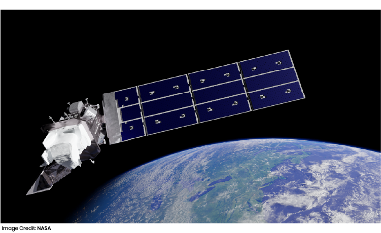
Interestingly! Landsat satellites orbit Earth and collect detailed images of forests, cities, deserts, glaciers, and water bodies.
So, in simple words, Landsat acts like a giant camera in space that continuously photographs Earth.
History of the Landsat Mission
NASA launched Landsat 1 on July 23, 1972, beginning a revolutionary era in Earth science. Since then, eight Landsat satellites have been launched successfully, each improving Earth observation technology while preserving long-term scientific consistency.
Landsat Timeline:
|
Satellite |
Launch Year |
|
Landsat 1 |
1972 |
|
Landsat 2 |
1975 |
|
Landsat 3 |
1978 |
|
Landsat 4 |
1982 |
|
Landsat 5 |
1984 |
|
Landsat 7 |
1999 |
|
Landsat 8 |
2013 |
|
Landsat 9 |
2021 |
Moving ahead, NASA is also preparing Landsat Next, which will further improve Earth monitoring.
How NASA’s Your Name in Landsat Tool Works
NASA developed the Your Name in Landsat interactive to celebrate Earth Day and increase public interest in Earth science. Users can type their name, and the system creates it using real satellite images of landscapes that resemble letters.
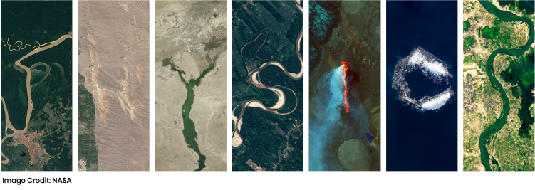
Now, let's discuss a few steps to understand how it works,
- Enter your name
- NASA’s system matches each letter with satellite images of landscapes that naturally resemble alphabet shapes
- These letters can come from deserts, rivers, forests, farms, lakes, or urban patterns
- Every selected image is an authentic Landsat satellite photograph
- Each letter also includes the exact geographic location or coordinates of where that image was captured
This means users not only see creative letter formations but also discover real places on Earth through satellite science.
Interestingly, each personalized name becomes a collection of global geographic locations, turning a fun activity into an educational experience.
Users can also study where each image originates, learn about different landscapes, and better understand how Landsat captures images of Earth from space.
Landsat’s Societal Benefits: How NASA Supports Life on Earth
NASA’s Landsat mission plays a critical role in helping humanity manage land, water, food, and natural resources as the global population continues to grow.
The fact is, humans currently use nearly 80% of Earth’s land surface, and with the population expected to approach 10 billion by 2050, sustainable land management has become more important than ever.
But the most important question arises: why does Landsat matter for society?
Landsat offers continuous monitoring of global land use, long-term environmental change records, reliable agricultural assessments, water resource monitoring, disaster response support, biodiversity protection, and urban growth analysis.
Here are the important societal benefits of Landsat.
Agriculture and Food Security
Let’s try to understand one of Landsat’s biggest contributions. Landsat helps monitor crop health, soil conditions, irrigation efficiency, drought patterns, and food production trends.
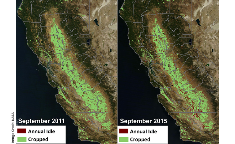
This supports farmers, governments, and food organizations in making better decisions about food supply and farming sustainability.
Disaster Management
Now the obvious question is: how does Landsat help during emergencies?
Landsat provides critical large-scale views during floods, wildfires, hurricanes, tornadoes, and droughts.
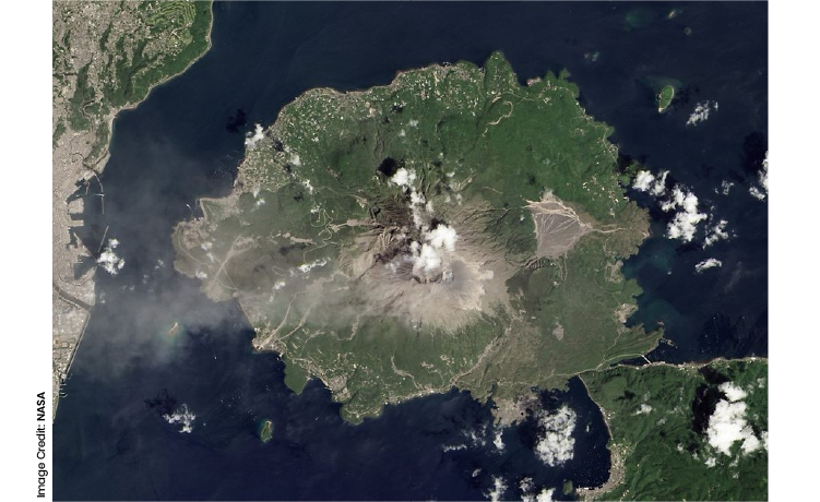
Remote sensing often becomes the only practical way to assess widespread disaster damage quickly.
Ecosystems and Biodiversity
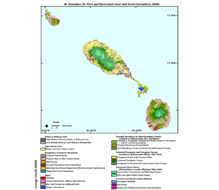
Interestingly! Landsat supports the protection of forests, wetlands, coral reefs, grasslands, and coastal zones. By monitoring environmental changes, scientists can better protect ecosystems that support both wildlife and human survival.
Energy Resource Management
Landsat also assists in locating potential energy resources such as oil, natural gas, geothermal vents, coal, and uranium deposits, monitoring mining activity, tracking environmental damage, and observing land recovery after extraction.
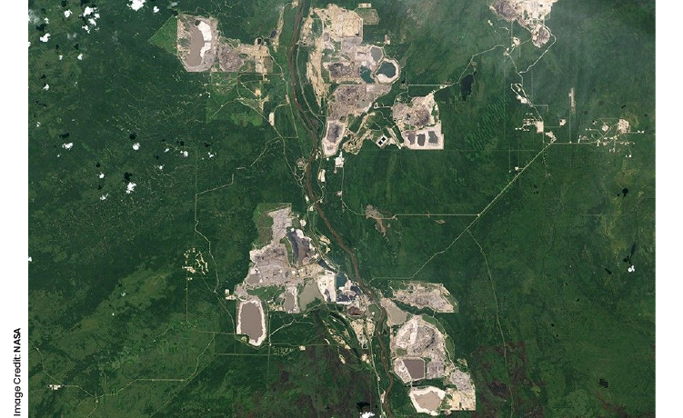
This helps balance energy needs with environmental responsibility.
Forest Management
Forests provide carbon storage, timber, biodiversity, and flood control. soLandsat tracks deforestation, pest outbreaks, forest degradation, and wildfire impacts.
.webp "Canadian Forest Ecosystem Changes and Biomass Trends (1985–2016)")
This makes it an essential tool for conservation.
Human Health Applications
Now you may ask: how can satellite images affect health?
.webp "Landsat 8 Natural Color Image of Sanaa, Yemen (June 2024)")
Landsat data helps identify environmental factors linked to diseases, including:
- Standing water for mosquito-borne illnesses
- Heat island effects
- Air quality issues
- Water contamination risks
Urban Development
Moving further, Landsat supports growing cities by monitoring urban sprawl, infrastructure growth, land conversion, and population expansion.
.webp "Landsat 8 Image of Chicago Highlighting Green Roof Temperature Impact (July 2019)")
Its 30-meter resolution is especially useful for mapping human impacts on land.
Water Resource Management
Water is essential for all life. Landsat helps with reservoir monitoring, river health, groundwater studies, drought analysis, and pollution tracking.
.webp "Natural-Color Landsat 8 Image of Siling Lake, Tibet (September 2017)")
Millions benefit from Landsat-based water management decisions worldwide.
Wildfire Monitoring
Have you ever noticed how wildfires are becoming more intense?
.webp "Landsat 8 Image of California Camp Fire Rapid Spread (November 2018)")
Landsat helps scientists measure burn severity, monitor forest recovery, assess fire spread, and improve prevention planning
Landsat is far more than a satellite mission; it is one of humanity’s most important tools for observing Earth and managing its future. NASA’s viral “Your Name in Landsat” campaign has shown how science can become interactive and accessible, inspiring millions to connect personally with Earth observation technology. As NASA prepares for Landsat Next, this mission will continue advancing scientific discovery while helping society make smarter decisions for a sustainable future.
Frequently Asked Questions on Landsat
1. What is Landsat?
Landsat is a NASA-USGS satellite mission that continuously captures scientific images of Earth’s land surface.
2. When was Landsat first launched?
Landsat 1 launched on July 23, 1972.
3. Why is Landsat important?
Landsat helps monitor Earth’s environment, climate, agriculture, and natural resources over time.
4. What is Your Name in Landsat?
It is NASA’s interactive tool that creates names using real satellite images shaped like letters.
5. Are Landsat images free?
Yes, NASA and USGS provide Landsat data freely to the public.
6. What are images of Earth from space used for?
They help with environmental research, farming, urban planning, and disaster management.
Science isn't just a subject, it's the way of seeing the world. Curious how Orchids The International School teaches it that way? Talk to our admissions team.
Admissions Open for 2026-27
What type of concept pages would you prefer?
CBSE Schools In Popular Cities
- CBSE Schools in Bangalore
- CBSE Schools in Mumbai
- CBSE Schools in Pune
- CBSE Schools in Hyderabad
- CBSE Schools in Chennai
- CBSE Schools in Gurgaon
- CBSE Schools in Kolkata
- CBSE Schools in Indore
- CBSE Schools in Sonipat
- CBSE Schools in Delhi
- CBSE Schools in Rohtak
- CBSE Schools in Bhopal
- CBSE Schools in Aurangabad
- CBSE Schools in Jabalpur
- CBSE Schools in Jaipur
- CBSE Schools in Jodhpur
- CBSE Schools in Nagpur
- CBSE Schools in Ahmednagar
- CBSE School In Tumkur











Orchids The International School is one of India's leading chains of CBSE and ICSE schools, with 130+ schools across the country.